
Jasper國家公園是加拿大著名高山國家公園之一,也是加拿大洛磯山脈最大型的的國家公園。位於Alberta(亞伯達省)洛磯山脈最北邊,在Banff國家公園的北面及Edmonton(艾德蒙頓)的西面。風景秀麗,環境優美,有多種野生動植物生長其中。占地面積10,878平方公里。

Columbia Ice-field
|
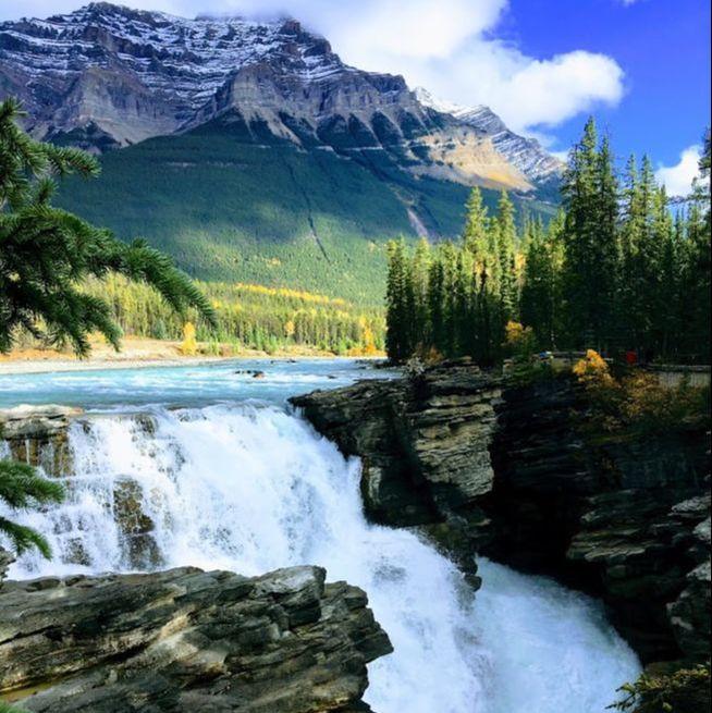
Athabsca Falls
|
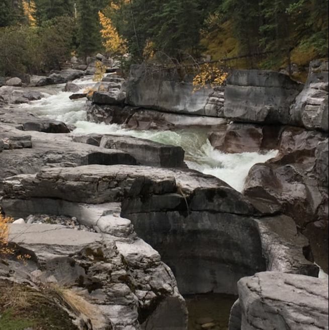
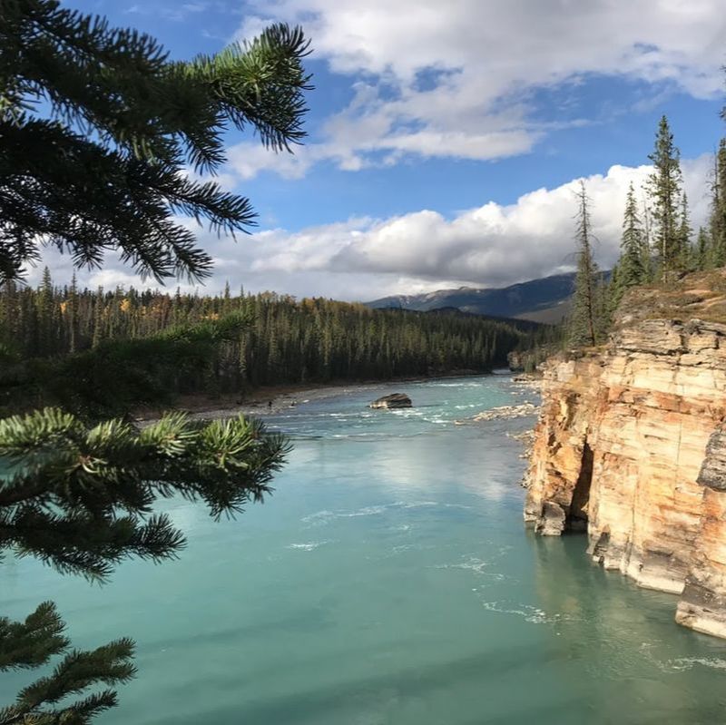
Maligne Canyon
|
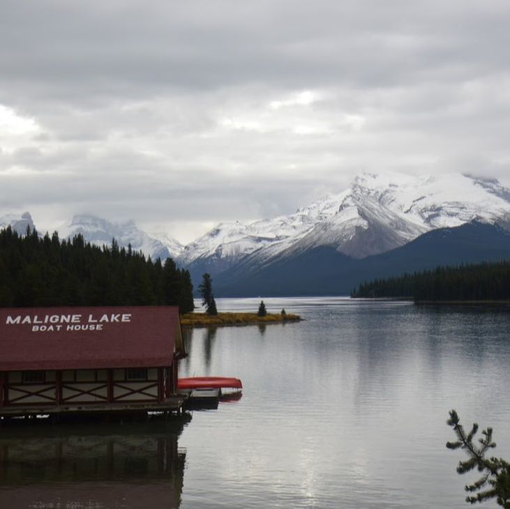
Maligne Lake
|
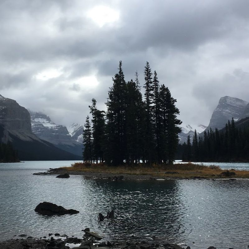
精靈島
|
|
Maligne Canyon Trail
Trailhead: Park at one of the bridge parking lots 10kms northeast of Jasper in Jasper National Park. The lowest 6th bridge parking lot is located 2kms form Jasper.
Description: This is more of a short walk than a hike but it can be extended if you start at the lowest sixth bridge downstream of the canyon. You can also drive to the top of the canyon and take a short walk to the Maligne Canyon lookouts which is what most of the tourists do. If you want to get out for a short easy hike start at the bottom sixth bridge parking lot. Cross the bottom bridge over the Maligne River then turn right onto the Maligne Canyon trail. The trail runs upstream along the Maligne River canyon. Between the sixth and fifth bridge there are several interesting underground streams that bubble up out of the ground and join the main river. When you arrive at the fifth bridge stay on your left, keep going straight ahead up the canyon trail. From this point the sharp canyon walls start to take shape and the trail now has a steel guard rail. Keep working your way up the canyon and cross the lookout bridges 4, 3, 2 and 1. Do not venture of the trail or over the guard rails as a fall into the canyon would be fatal. Maligne Canyon is one of the deepest river canyons found in the Canadian Rockies. The majority of the river runs 32km underground from Medicine Lake to the Athabasca River. Depending on the rivers flow rate, sections of the canyon and the river bed can become completely dry. The upper trail and it's 4 bridges offer outstanding views of crystal clear pools that have eroded into the rock along with several waterfalls. Maligne Canyon's deepest point is approximately 55m. In spots the canyons top opening is only 2m across. During the winter months most of the canyon is a frozen wonderland.
Description: This is more of a short walk than a hike but it can be extended if you start at the lowest sixth bridge downstream of the canyon. You can also drive to the top of the canyon and take a short walk to the Maligne Canyon lookouts which is what most of the tourists do. If you want to get out for a short easy hike start at the bottom sixth bridge parking lot. Cross the bottom bridge over the Maligne River then turn right onto the Maligne Canyon trail. The trail runs upstream along the Maligne River canyon. Between the sixth and fifth bridge there are several interesting underground streams that bubble up out of the ground and join the main river. When you arrive at the fifth bridge stay on your left, keep going straight ahead up the canyon trail. From this point the sharp canyon walls start to take shape and the trail now has a steel guard rail. Keep working your way up the canyon and cross the lookout bridges 4, 3, 2 and 1. Do not venture of the trail or over the guard rails as a fall into the canyon would be fatal. Maligne Canyon is one of the deepest river canyons found in the Canadian Rockies. The majority of the river runs 32km underground from Medicine Lake to the Athabasca River. Depending on the rivers flow rate, sections of the canyon and the river bed can become completely dry. The upper trail and it's 4 bridges offer outstanding views of crystal clear pools that have eroded into the rock along with several waterfalls. Maligne Canyon's deepest point is approximately 55m. In spots the canyons top opening is only 2m across. During the winter months most of the canyon is a frozen wonderland.
Moose Lake Loop
2.7 km loop; 59 m elevation gain; 1-2 hours
Trailhead: Start on the Bald Hills Trail (see bellow), then branch left after 200 m onto the Maligne Pass Trail toward Moose Lake.
This trail stays in the woods, but the landscape is fascinating: little hills and hollows among the overgrown debris of a huge landslide. Thousands of years ago, half a billion cubic metres of rock fell from the ridge on the other side of Maligne Lake, blocking the valley and enlarging the lake considerably to its present size. The mossy, lichen-encrusted boulders seen along the trail—a natural rock garden—are part of the slide heap. Dark-brown hair lichens adorn the bare branches of lodgepole pines.
After a short section over relatively level terrain, turn left off the Maligne Pass Trail to reach Moose Lake, which lies in a hollow in the rockslide debris. From the lake the trail continues gently downhill to Maligne Lake. Keep left along the shore to return to the parking lot.
Pyramid Trail
The Pyramid Trail is commonly used as a hiking connector/freeway to the Pyramid Bench and Pyramid Lakes trail systems.
Hiking Distance It is 5.2 km one way.
Hiking Time The Pyramid Trail takes 1-2 hours to hike.
118 m Elevation gain.
Getting There
The Pyramid Trail hiking trailhead can be found in the Jasper Activity Centre's parking lot.
Hiking Distance It is 5.2 km one way.
Hiking Time The Pyramid Trail takes 1-2 hours to hike.
118 m Elevation gain.
Getting There
The Pyramid Trail hiking trailhead can be found in the Jasper Activity Centre's parking lot.
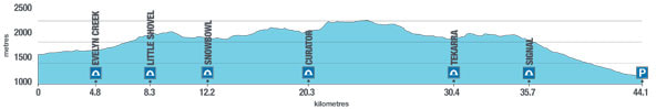
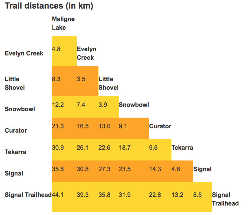
Skyline Trail
|
|
With almost 25 km of this trail hiked above treeline, the Skyline is Jasper’s highest and possibly most scenic trail. The high elevation allows for amazing views that extend over much of the park, encompassing vast meadows, windswept ridges and the chance to spot wildlife in the distance. Crossing three mountain passes, the Skyline trail offers a variety of flora, fauna and scenery unique to Jasper National Park. Be prepared for all weather conditions, and always check current conditions before setting off. Snow can fall any time of the year, and the section of trail called “the Notch” can be impassable early in the season.
|
|
Directions to trailheadMaligne Trailhead (south)
Take Highway 16 East towards Edmonton. Two km from Jasper, turn right across the bridge onto Maligne Road. Continue for 46 km south on the Maligne Road to Maligne Lake. Continue on the road past the chalet and across the bridge to the parking lot on the west side of the lake. The trailhead is on the right-hand side of the road, just before you reach the parking lot. Signal Trailhead (north) Drive 8 km south on the Maligne Lake Road. Parking area is on the right. https://www.pc.gc.ca/en/pn-np/ab/jasper/activ/passez-stay/arrierepays-backcountry/sugg-sentiers_trip-ideas/Skyline
|
|

華岡羅浮股份有限公司│23155新北市新店區黎明路65巷15號
FB搜尋:SC-OUTING│ E-mail:[email protected]
協辦旅行社:『大道旅行社』( 交觀甲028600, 品保編號: 北07730001)
FB搜尋:SC-OUTING│ E-mail:[email protected]
協辦旅行社:『大道旅行社』( 交觀甲028600, 品保編號: 北07730001)
